Tag Archive for: NOAA

Major Ocean Research Effort Centered in San Diego

The Scripps Institution of Oceanography in San Diego will host a major research initiative funded by the federal government.

UC San Diego will host the Cooperative Institute for Marine, Earth and Atmospheric systems, and it will get up to $220 million in funding for research over a five-year period.

The National Oceanic and Atmospheric Administration is making the investment locally after a competitive bidding process.

Unusually Warm May Contributes to Expanding Drought in the West

The Western drought has continued to expand and intensify, according to U.S. Drought Monitor data released Thursday.

Wet late-spring weather resulted in a slight decrease in the area deemed to be in extreme drought in Northern California.

Severe drought receded a little in parts of northeastern Utah and southwestern Washington. Unseasonably heavy precipitation, including high-elevation snow, fell in northeastern Utah, the Drought Monitor reported

This Year is on Track to be Earth’s Warmest on Record, Beating 2016, NOAA says

There is a 75 percent chance 2020 will set a record for the warmest year since instrument records began in 1880, the National Oceanic and Atmospheric Administration is projecting, beating out 2016 for the distinction.

This is somewhat unexpected, since there is no declared El Niño event in the tropical Pacific Ocean, which tends to provide a natural boost to global temperatures that are already elevated due to the human-caused buildup of greenhouse gases in the atmosphere.

The NOAA projection, made late last week, is based on statistical modeling now that the first quarter of 2020 is off to a near-record warm start, coming in as the second-warmest January through March period since instrument records began in 1880.

California Drought: Northern California Having Driest February Since 1864

With unusually dry, hot weather continuing for weeks on end and the driest February in the Bay Area in 156 years, nearly a quarter of California’s land area now is under drought conditions, federal officials announced Thursday.

Altogether, 23.3% of the state is in “moderate drought” — up from 9.5% last week, according to the U.S. Drought Monitor, a weekly report issued by the National Oceanic and Atmospheric Administration, the U.S. Department of Agriculture and the University of Nebraska-Lincoln.

March Outlook from NOAA’s Climate Prediction Center

NOAA’s Climate Prediction Center issued their outlook for March late last week, with a colder month expected ahead for many areas of the nation. Below average temperatures are forecast from the Northeast southward through the Tennessee Valley and Southern Plains to the Gulf of Mexico. Warmer than normal temperatures are favored in the Southwest.

UCSD Scientists Will Ride Research Aircraft into Huge Storms to Study Atmospheric Rivers

UC San Diego will send airborne scientists into huge offshore storms to deepen their understanding of ”atmospheric rivers,” the plumes of moisture that can bring nourishing rains, and flooding, to the West Coast.

The second of up to 12 winter weather reconnaissance flights is scheduled to take off from Travis Air Force Base near Sacramento on Tuesday, carrying researchers from NOAA and the Air Force. UCSD will add its own researchers to the trips in about a week.

The university is partnering with the government and military on the project, which is being run out of the UCSD’s Scripps Institution of Oceanography.

Atmospheric Rivers Drive Western U.S. Flood Damages

New research recently published in Science Advances found that atmospheric rivers accounted for 84% of flood damages, or $42.6 billion, across the western United States from 1978-2017. Supported by NOAA’s Regional Integrated Sciences and Assessments (RISA) and co-authored by California-Nevada RISA PI Alexander Gershunov, the study analyzed 40 years of data from the National Flood Insurance Program to quantify atmospheric rivers’ economic impacts.

Lack of Rain Puts Signs of Drought Back on California Map

Little rain has fallen in California since the start of the water year on Oct. 1, putting signs of drought back on the map.

The federal Drought Monitor Map, a mechanism to measure drought that’s mainly used in agriculture, shows 81% of the state as abnormally dry. A small portion (4%) of the map near the Arizona border is designated as “moderate drought.”

Winter 2019-20 Will Likely Be Warmer Than Average in Southern U.S. & Colder Than Average in Parts of Northern Tier

A warmer winter is in store for much of the southern U.S., while the northern tier of the country shivers, our new winter outlook shows. In addition, NOAA’s winter outlook indicates that parts of the flood-weary Northern Plains and Midwest may see a wetter-than-average December through February.

Winter temperatures will likely be near to warmer than average for much of the southern U.S., but parts of the northern tier won’t be so lucky. Temperatures there are projected to be near to slightly below average.

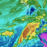
GOES satellite image of the atmospheric river phenomena from March 20, 2018.

California Funds Atmospheric Rivers Research

A better understanding and forecasting of atmospheric rivers could improve flood control and water management in California.

The 2019-20 California state budget includes $9.25 million to pay for research into how the state Department of Water Resources can more accurately track the intensity and landfall locations of atmospheric rivers. About half of the state’s annual rainfall and 90 percent of its flooding come from such events.

“Improved forecasting and monitoring of atmospheric river storms would benefit not only California, but the Southwest, in managing our water supply,” said Kelley Gage, director of water resources for the San Diego County Water Authority. “With better forecasting, water managers could also prepare and plan for flooding events caused by the atmospheric rivers.”
The science behind atmospheric rivers

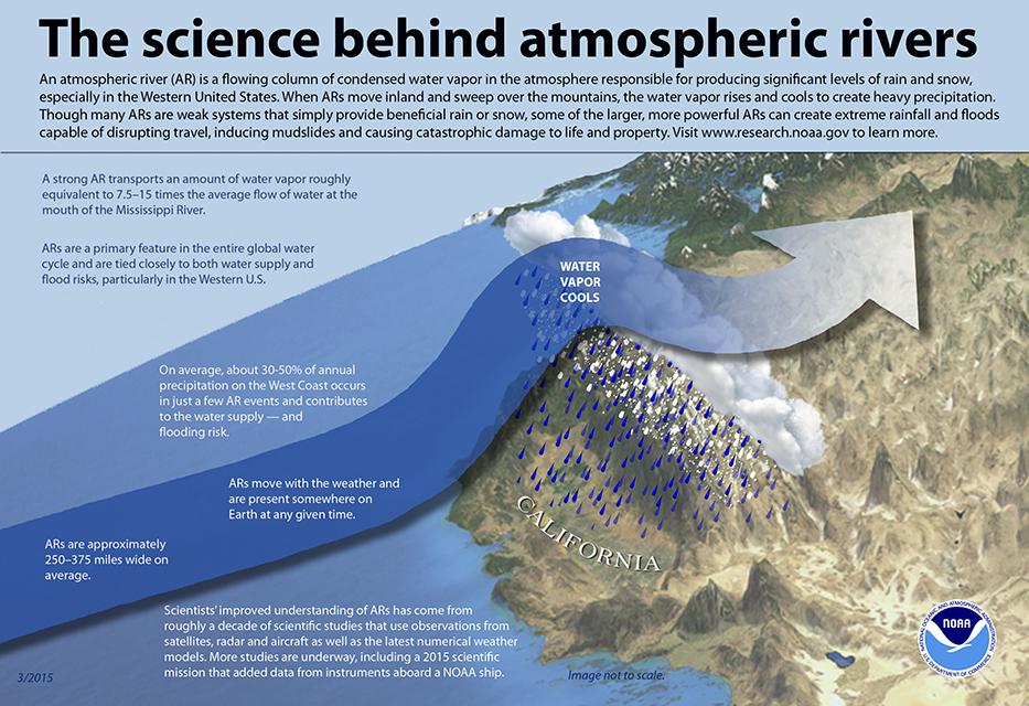
The science behind atmospheric rivers. Graphic: NOAA

Rivers in the sky

Atmospheric rivers are relatively long, narrow regions in the atmosphere – like rivers in the sky – that transport most of the water vapor outside of the tropics, according to NOAA. When the atmospheric rivers make landfall, they release the water vapor in the form or rain or snow.

“The rivers can stretch from 250 to 370 miles wide and carry a water amount more than 7 times the volume of the Mississippi River,” said Alexi Schnell, water resources specialist with the Water Authority.

The research funds were allocated to the Department of Water Resources to “improve observations, forecasts and decisions in support of atmospheric river precipitation events” as part of the DWR’s Research, Mitigation, and Climate Forecasting Program.

Atmospheric Rivers

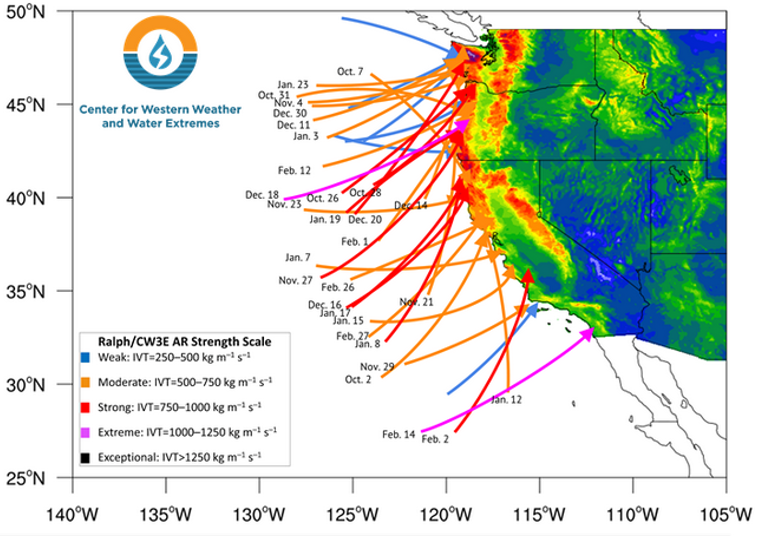
Atmospheric Rivers in Water Year 2019. Graphic: Center for Western Weather and Water Extremes

Volatile water resources

A new study led by Scripps Institution of Oceanography at UC San Diego suggests that a new regime of wet and dry extremes is emerging in California. The study shows that the projected increase of extreme precipitation is likely to be caused by streams of moisture in the sky known as atmospheric rivers.

The study was published July 9 in the journal Nature Scientific Reports.

“California already has the most volatile water resources in the country,” according to a news release from Scripps. “Scripps scientists discovered that the state’s precipitation, as it becomes less frequent but preferentially stronger, will vacillate even more wildly between extremes of drought and flooding as a consequence of climate change.”

The federal Bureau of Reclamation, the Southwest Climate Adaptation Science Center, NOAA, the U.S. Geological Survey, and NASA funded the study, “Precipitation regime change in Western North America: The role of Atmospheric Rivers.”

California weather extremes

“As Mediterranean climate regions around the world are becoming more subtropical, the dry season is expanding. California is no exception,” said Alexander Gershunov, a climate scientist at Scripps. “What is exceptional about California is that the heavy precipitation is projected to become more extreme. We knew this from our past work. Now we have identified the mechanism responsible for this bolstering of extremes, and that gives us a more nuanced understanding of what to expect from future hydroclimate and a clearer interpretation of ongoing changes.”
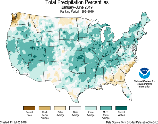
 

Atmospheric Rivers helped California's snowpack in Winter 2018-19.

For the year-to-date 2019, the precipitation total was 19.05 inches, 3.74 inches above average, and the wettest such period in the 125-year record. Graphic: NOAA

Atmospheric Rivers boost snowpack

During the 2018-19 winter, atmospheric river events significantly increased snowpack in the Sierra Nevada and the Rocky Mountains. Both areas are key sources of water supply for the Southwest, including California and San Diego County.

Precipitation in the contiguous U.S. was above average from January to June 2019, according to a NOAA climate report released this week. The report said the 19.05 inches during the six-month period was 3.74 inches above average and the wettest such period in the 125-year record.

The January-to-June 2019 precipitation map showed California’s statewide precipitation was “above average” and “much above average.”